MAPCO
MAPCO
Map Of London 1851 - Cross's London Guide MAPCO
MAPCO Store
MAPCO


Map Of London 1851 - Cross's London Guide


Kilburn Wells & Grand Junction Canal Primrose Hill, Portland Town, St. John's Wood, Lord's New Cricket Ground, & Regent's Park Camden Town, Regent's Park, Somers Town, North Western Railway Depot, Coliseum, Diorama, & Tottenham Court Road Agar Town, Pancras, Somers Town, Great Northern Railway, King's Cross, Foundling Hospital, & Russell Square Islington, Regent's Canal, New River Head, Clerkenwell Green, & Charter House Gardens Kingsland, Regent's Canal, Hoxton, & Shoreditch Hackney, Regent's Canal, Victoria Park, Globe Town, & Bethnal Green Victoria Park, Globe Town, Mile End Road, & Tower Hamlets Cemetery
Great Western Railway Depot, Porchester Square & Kensington Gardens Edgeware Road, Paddington, The Uxbridge Road, Kensington Gardens, Hyde Park, Park Lane, The Site Of The Great Exhibition Of 1851, & Knightsbridge Portland Place, Oxford Street, Grosvenor Square, Regent Street, Park Lane, Hyde Park Corner, Piccadilly, Green Park, The Queen's Palace, Pall Mall, & St. James's Park British Museum, Red Lion Square, Grays Inn Gardens, Holborn, Lincolns Inn Fields, Trafalgar Square, Charing Cross, Strand, Waterloo Bridge, Hungerford Suspension Bridge, Whitehall, Westminster, Houses Of Parliament, Westminster Abbey, & Lambeth Holborn Hill, West Smithfield, Aldersgate, Ludgate Hill, St. Paul's Cathedral, Cheapside, Poultry, Blackfriars Bridge, Southwark Bridge, London Bridge, & Southwark Bishopsgate Street, Houndsditch, Cornhill, White Chapel, East Smithfield, The Tower, St. Catharine's Dock, London Dock, Bermondsey, & Rotherhithe Mile End Road, Stepney, London Dock, East London Dock, Upper Shadwell, The Pool, & Rotherhithe Stepney, Bow Common, Limehouse Hole, Commercial Dock, & West India Dock
Kensington New Town, Earl's Court, London & Westminster Cemetery, & Old Brompton Brompton, Road To Putney, Queens Elm, Sloane Square, The King's Road, Chelsea Hospital, & Chelsea The Queen's Mews, Victoria Street, Pimlico, Grosvenor Canal, Chelsea Hospital Gardens, Chelsea, & Millbank Westminster, Houses Of Parliament, Millbank Penitentiary, Millbank, Lambeth Palace, Lambeth, Vauxhall Bridge, Vauxhall Gardens, & Nine Elms Bethlem Hospital, Borough Road, County Gaol, New Kent Road, Newington, Zoological Gardens, Walworth New Town, & Walworth Bermondsey, Walworth, London & Greenwich Railway, Bricklayers Arm Branch Railway, Old Kent Road, & Surrey Square Rotherhithe, Grand Surrey Inner Dock, London & Greenwich Railway, Bricklayers Arm Branch Railway, Croydon Railway, & Deptford Lower Road Commercial Docks, Limehouse Hole, Isle Of Dogs, The Kings Dock Yard, & Deptford


Click Here To View The Map Image Without Borders


The Map

Full Title:
Cross's London Guide
Label Title:
Cross's London Street Directory 1851
Publisher:
J. Cross, 18, Holborn Hill, opposite Furnivals Inn.
Date:
1851
Size:
72cm x 43.7cm (28½" x 17¼")
Scale:
3½" : 1 statute mile
Extent:
Islington - Limehouse - Walworth - Kensington.
Description:
Folding map of London. Printed on silk. Hand coloured. Paper label adhered to back of silk. Title set in top border. Explanation of colours and imprint set in bottom border. No date on map. Map divided into half mile squares and margins lettered and numbered for reference. References to Public Buildings, Exhibitions &c., Theatres, Police Offices, and Miscellaneous Buildings below bottom margin. Decorative motifs at corners. Howgego No. 360 (4)

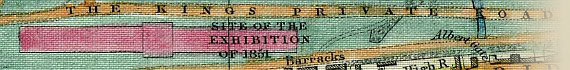
This 1851 map of London by Joseph Cross was produced for visitors to London during the Great Exhibition of 1851 in Hyde Park. This map is unique amongst the MAPCO collection as it printed on silk, the texture of which is clearly visible in the scans. It has suffered some staining over the years, the eastern sections of the map having a water stain showing over the entire height of the map. Despite this flaw the map is in excellent condition for its age, given that it is printed directly onto silk and is not reinforced in any way. The hand colouring is still bright and vibrant after 156 years.


Click To View The Site Of The Great Exhibition Of 1851 In Hyde Park

View The Site Of The Great Exhibition Of 1851 In Hyde Park


The references to public buildings, etc., at the bottom of the map will be displayed here soon.

Genealogists and family historians will find this map of London a great aid for finding streets in the 1851 Census.


How To Use These Map Pages

Use the thumbnail map at the top of each page to navigate your way around the map.

Hovering your mouse pointer over the thumbnails will highlight the individual sections, and display a pop-up message showing the areas covered by that section of the map. Click the desired area to jump to a page displaying a full size image of the map section. You will need to scroll down the page a little to see the image of the map.

A coloured thumbnail image on the thumbnail map at the top of the page will show you which section of the entire map you are currently viewing.


Click To Enlarge

Once you are viewing the desired map section, you can click on the map image to view an enlarged image of that section.

Clicking on the map images allows you to switch back and forth ('toggle') between the normal sized image and the enlarged view of the section.


Date


This site has been accessed Counter times.


Copyright Date